

LiDAR Drone Market: Navigating the Future of Geospatial Data and Industrial Automation by 2031
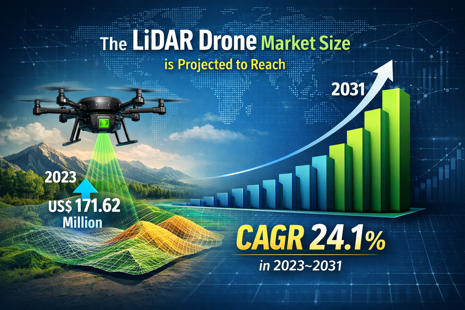
The integration of Light Detection and Ranging (LiDAR) technology with Unmanned Aerial Vehicles (UAVs) has fundamentally altered how industries perceive and interact with the physical world. By utilizing laser pulses to measure distances and create highly accurate 3D representations of terrain and objects, LiDAR drones have moved from niche scientific tools to essential industrial assets. According to recent industry valuations, the LiDAR drone market size is projected to reach US$ 965.27 million by 2031 from US$ 171.62 million in 2023. The market is expected to register a CAGR of 24.1 % in 2023–2031. This trajectory highlights a significant shift toward high precision automation across global supply chains and infrastructure projects.
The Evolution of Aerial Sensing
Historically, LiDAR technology was the exclusive domain of large scale manned aircraft missions due to the immense weight and power requirements of the sensors. The breakthrough for the current market came with the miniaturization of laser scanners and the improvement of drone battery density. Today, a drone can carry a payload that provides centimeter level accuracy while flying under canopy covers or in complex urban canyons where GPS signals might struggle.
The transition from mechanical scanning LiDAR to solid state LiDAR is another pivotal technical milestone. Solid state sensors, which have no moving parts, are more durable, lighter, and increasingly cost effective. This shift has lowered the barrier to entry, allowing smaller surveying firms and municipal governments to adopt the technology for routine inspections and localized mapping.
Download Sample PDF Report:https://www.theinsightpartners.com/sample/TIPTE100000453
Drivers of Market Expansion
Several factors are propelling the rapid adoption of these systems. In the construction industry, LiDAR drones provide a "digital twin" of a job site in a fraction of the time required by traditional ground surveying methods. This allows project managers to track progress, identify deviations from blueprints, and manage resources with unprecedented efficiency.
In the forestry and environmental sector, the ability of LiDAR to "see through" dense vegetation to map the forest floor (ground classification) is a game changer. It allows for accurate biomass estimation, flood modeling, and the planning of precision logging operations that minimize environmental impact. Furthermore, as the world moves toward more sustainable energy sources, the utility of LiDAR drones in inspecting wind turbine blades and mapping corridors for high voltage power lines has become indispensable.
Strategic LiDAR Drone Market Opportunities
The landscape is currently ripe with LiDAR drone market Opportunities that extend far beyond simple mapping. One of the most significant areas for growth lies in the development of automated data processing pipelines. As drones collect billions of data points (point clouds), the bottleneck is often the human labor required to clean and categorize that data. Companies that develop AI driven software capable of automatically identifying structural defects in bridges or counting specific tree species in a forest are positioned to capture a massive secondary market.
Another burgeoning opportunity is found in the "Smart City" initiatives gaining momentum globally. LiDAR drones are being utilized to create high definition maps for autonomous vehicle navigation. These maps require constant updates to reflect changes in road layouts or urban furniture, creating a recurring demand for drone based LiDAR services. Additionally, the integration of LiDAR with other sensors, such as thermal or multispectral cameras, allows for multi layered data sets that provide a holistic view of asset health, offering a comprehensive service package to industrial clients.
Regional Growth and Regulatory Landscape
While North America remains a dominant force due to its robust defense and infrastructure sectors, the Asia Pacific region is rapidly emerging as a high growth hub. Rapid urbanization in India, China, and Southeast Asia necessitates rapid land surveying and infrastructure monitoring. Governments in these regions are increasingly supportive of drone technology, viewing it as a tool for economic modernization and disaster resilience.
Regulatory frameworks, such as the FAA’s Part 107 in the United States and similar EASA regulations in Europe, have provided a clearer path for commercial operations. As Beyond Visual Line of Sight (BVLOS) waivers become more common, the operational range of LiDAR drones will expand, further increasing their ROI for long linear infrastructure like pipelines and railways.
Key Players in the LiDAR Drone Market
The market is characterized by a mix of established sensor manufacturers and specialized drone platform providers. These organizations are focusing on "plug and play" systems that reduce the technical expertise required by the end user. Key players include:
-
DJI (Da-Jiang Innovations) – A leader in integrated drone platforms and accessible LiDAR payloads.
-
Phoenix LiDAR Systems – Known for high end, multi sensor integration and custom solutions.
-
Velodyne Lidar, Inc. – A pioneer in compact, high performance laser sensors.
-
YellowScan – Specializes in lightweight, ultra accurate LiDAR for professional UAVs.
-
Riegl Laser Measurement Systems – Provides high grade scanners for long range and high altitude missions.
-
Microdrones – Offers fully integrated hardware and software workflows for surveying.
-
Teledyne Optech – Focuses on advanced lidar and photogrammetry solutions.
-
Leica Geosystems (Hexagon AB) – A titan in the geospatial industry with robust aerial sensing divisions.
-
Faro Technologies – Known for 3D measurement and imaging solutions.
-
Sick AG – A major player in industrial sensors and automation technology.
Future Outlook
The future of the LiDAR drone market will be defined by the convergence of edge computing and real time analytics. We are moving toward an era where the drone does not just record data for later analysis but processes it in flight to make autonomous decisions. For instance, a drone inspecting a power line might detect a frayed wire using LiDAR and immediately slow down or change its flight path to capture higher resolution imagery of the fault. As the cost of sensors continues to decline and AI becomes more adept at handling large datasets, LiDAR drones will become as ubiquitous on construction sites and farms as the GPS is today. This will lead to a more "measurable" world, where precision data informs every step of industrial and environmental management, ultimately driving the market toward its nearly billion dollar potential by 2031.
Related Reports:
About Us
The Insight Partners is a leading global market research and consulting firm specializing in delivering actionable insights across various industries. Our research reports combine extensive primary and secondary research to provide accurate market intelligence, helping businesses make informed strategic decisions. The company provides detailed analysis on emerging technologies, market trends, competitive landscapes, and growth opportunities across sectors including technology, healthcare, manufacturing, and energy.
Contact Us
The Insight Partners
Phone: +1-646-491-9876
Email: sales@theinsightpartners.com
Website: https://www.theinsightpartners.com